A regional climate model for high-impact weather
Australia’s climate simulator (ACCESS-NRI) has released a fully supported version of a regional climate model that enables researchers to understand high-impact weather events like hurricanes, floods and droughts, which are not captured by the wide-angle lens of global climate models.
Regional climate models are game changers when it comes to simulating high-impact weather events, and they’re particularly important for unique landscapes like Australia. While global climate models capture the big picture across the planet, they miss local high-impact weather events such as bushfires and storms or the effect of mountains over the local weather. Regional models are like switching from binoculars to a magnifying glass, showing much more detail about what’s happening locally.
“We run global models to understand changes of the whole planet over longer time scales. However, this means we’re limited in the resolution we can use, because it requires much more computing power. A global model can’t capture extreme weather events. So, we run regional models, which focus on a limited region at high resolution. For example, the Blue Mountains are invisible to a global model, but very important for the weather affecting people living in the Sydney area,” says Dr Martin Dix, Associate Director for Model Development at ACCESS-NRI.
To address this challenge, Australia’s climate simulator (ACCESS-NRI) has released ACCESS-rAM3, a fully supported regional model, created to understand and project weather with a unique Australian focus. This model includes atmosphere and land components, and it is an implementation of the UK Met Office (UKMO) regional nesting suite.
Dr Heidi Nettelbeck, leader of the ACCESS-NRI Atmosphere Modelling team, which developed this model, says that “ACCESS-rAM3 allows Australian researchers to choose the time and location they wish to simulate. It also enables users to seamlessly use land-surface initial conditions from other available sources rather than relying on operational data, which are not readily available to the public”.
This model enables the vital research undertaken by 21st Century Weather, aiming to understand how Australia’s weather will transform as our climate changes.
Dr Mathew Lipson, a senior researcher at 21st Century Weather, UNSW Sydney, says that “the value of rAM3 is that it is an adaptable regional model that allows researchers to run experiments and simulations robustly and relatively easily, at any resolution that we are interested in. It is incredibly useful for researchers to have this ability to run simulations for any historical weather event, so we can understand processes at the scale that have an impact on society and environment.”
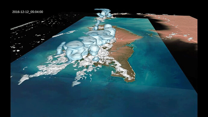
“I have used rAM3 to understand the effects of cities on the weather. We have run simulations over the greater Sydney region with and without cities to assess what is the urban impact in the local weather, asking questions like what happens in a heat wave? Or what happens when sea breeze is forming over a city?” he says.
A very important improvement on all the models released and supported by ACCESS-NRI is that it enables a much greater cohort of researchers to undertake modelling experiments, more easily. “Ten or twenty years ago it used to take more than 3 months to set up and start a model to undertake modelling experiments. In contrast, two weeks ago, I was able to take some PhD students with no model experience and get them to run rAM3 within a couple of hours,” says Dr Lipson.
The rAM3 model is specially designed to run on the National Computing Infrastructure (NCI) platform available to the Australian research community.
“You can’t just take a model from the UK Met Office and run it immediately on a local computer, as all the background engineering is very particular to the computing system that it’s run on. The ACCESS-NRI team has done all the fantastic background work of getting the model running and connecting all the pipes, so, researchers like me, can just pick it up and use it on our own Australian computing platform and with all the ongoing support that comes with it,” says Dr Bethan White, a senior researcher from 21st Century Weather, University of Melbourne.
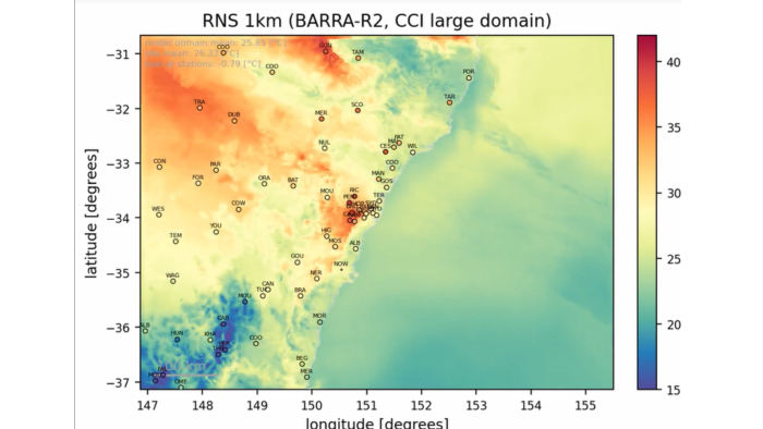
This model allows researchers to ask questions about large scale processes at a very fine scale, like how the weather systems form along the entire East Coast of Australia and how do tropical and extratropical interactions happen. Without the fine scale resolution, we can’t look at these processes” Dr Bethan White.
The Australian focus of this release has been enhanced by a new functionality introduced by ACCESS-NRI, an improvement of the soil moisture initialisation using ERA5-Land from the European Centre for Medium-Range Weather Forecasts (ECMWF) and the BARRA reanalysis from the Bureau of Meteorology.
The future for the next versions of the ACCESS regional model will be to connect the Australian developed land-surface model, CABLE, as it better represents Australian vegetation and soil. Currently, ACCESS-rAM3 uses the UKMO land-surface model JULES.
ACCESS-NRI modelling relies on computational and data resources operated by Australia’s National Computational Infrastructure (NCI). ACCESS-NRI and NCI are enabled by the Australian Government, Department of Education, through the National Collaborative Research Infrastructure Strategy (NCRIS).
Would you like to use this model? See its release information:
https://forum.access-hive.org.au/t/access-ram3-release-information/4308
https://access-hive.org.au/models/configurations/access-ram/
This article first appeared on www.access-nri.org.au. To read the original, go to: https://www.access-nri.org.au/access-ram3-regional-model/